PLANTING SITE SELECTION
Australian cedar clonal development has been exceptional, and the plants grow more than 3.0 m at 12 months of age. At 3 years, the trees are taller than 10 m. Customers reported from other states (São Paulo, Bahia, Rio de Janeiro) that the performance they had there was also being surprisingly good. Inventories showed annual productivity between 17m3 and 37m3 per hectare. This is the new reality of this crop, which before the clonal materials produced an average of 12m3/ha/year.
To achieve a forest with good productivity, one must be aware of soil conditions, local climate and rainfall. High productivity requires fertile soil and adequate rainfall; altitude and temperature are not the main limiting factors; the quality of Australian cedar seedlings is also very important. One also needs to have roads to the planting site, to facilitate planting, harvesting and the very removal of the logs. One should avoid areas of difficult access.
To choose the area where the crop is to be deployed, one should pay heed to the following items:
Physical predicaments
The ideal area has deep soils, free from physical impediments such as gravel and slabs, mainly. These problems cannot be overcome. One should avoid compacted, sandy and low fertility soils. Choose soils without rocks or gravel. Even mildly rocky soils are not recommended because they represent an impediment to root development. Make sure the area has a DEEP SOIL. Rock formations in the subsurface layer act as a deterrent and may also compromise tree sustainability.
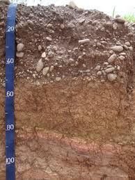
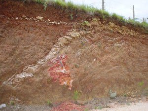
Rocky soils.
Fertility
Australian cedar grows best in alluvial soils near rivers and at the foot of slopes, in properly-corrected and fertile eutrophic latosol (V% between 50% and 60%). Medium texture soils (not too clayey or too sandy) are ideal because they respond well to correction and fertilization. Clayey soils require large amounts of fertilizer, and very sandy soils require fertilizer replacement more often. Fertile soils are the most suitable, they are popularly known as “crop land.”
Soil correction is needed for planting Australian cedar. DO NOT PLANT in acid soils.

Drainage
Choose well-drained soil sites for planting because the roots cannot stand waterlogging. AVOID planting in areas of permanent conservation – (around springs, banks of watercourses, hilltops, areas with steep slopes): besides the fact that this practice goes against the law, the species DOES NOT TOLERATE the typical wet environment of river banks.

Previous land use
Planting in areas newly planted with some culture yield greater development and vigor than in gross areas. This is due to the fact that the areas received soil corrections like fertilization, liming or gypsum administration. Soils newly planted with corn and coffee yield excellent crop outcomes.
Temperature
Frost-free areas (withstands light and short duration frosts) and without recurrent hailstorms make the best planting grounds. Cedar is sensitive to strong and constant frosts. AVOID areas with a history of periodic frosts or hailstorms.
Altitude
Altitudes up to 1,200m (provided they are not shallow or field soils).
Topography
Land topography does not affect forest quality and productivity; however, the impossibility of mechanizing operations increases the cost of implementation and management of the forest, as well as the cost of harvesting and timber removal. This factor can derail forestry projects with species whose wood has less value in the market, such as eucalyptus, but this is not the case of Australian cedar or other highly valued tropical species.

Rainfall
Avoid areas with less than 1.300 mm of rainfall for non-irrigated crops. Well-distributed rainfall regimes during the year result in higher productivity. The maximum drought period should be of 6 months.
We recommend daily monitoring of rainfall after planting using a rain gauge.
Agroforestry systems (Integration Crop, Livestock and Forest)
The plant’s rapid growth enables its consortium with other activities: agriculture, in the first year; or livestock, from the second year on, which reduces the cost of maintaining the forest and generates early income. For the implementation of consortia, or agroforestry systems (AFS), we recommend larger spacing between the trees, that enables mechanization and increases area insolation. A good example is a consortium with coffee crops, which has shown great results for both crops; cedar benefiting from the soil treatment for coffee and improving the site condition, with coffee (“the beverage”) acquiring a better quality.

Soil sampling and analysis
In order to analyze the soil for forest species, we suggest that soil samples be collected at two depths per point (0-20 and 20-40 cm) under the following criteria (collection example for plot 1):
-Select the plots from where you will collect the samples. Very different areas of vegetation, gravel or change in soil color imply different plots.
-Within The plot, select the collection points through a cross-sectional zigzag pattern in order to collect samples from various locations in the area, so that it comes represented.
-Collect from at least 5 points per hectare.
-Clear excess vegetation off the surface exposing the ground without scraping it. Collect the same amount of soil from each point.
-In the case of using a post-hole digger, remember that the land must be removed from the side of the hole along the sampled depth, and not only from the bottom or the surface. Ideally, one should use an auger or probe.
-After the collection, remove excess organic matter such as twigs, weeds or roots from the sample. Mix the samples well and remove approximately 400g to send to the lab.
Example for 1 plot:
| Depth: | Plot | # of sampling spots |
Sample code | Analyses |
|---|---|---|---|---|
| 0-20 cm | T1 | 5 a 7/ha | 0-20-T1 | Fertility aluminum, organic matter, texture, sodium, V%, m%, sulphur, micros (boron, zinc, iron, manganese and copper) |
| 20-40 cm | T1 | 5 a 7/ha | 20-40-T1 | Fertility, sodium, aluminum, texture, V%, m%, sulphur, micros (boron, zinc, iron, manganese and copper) |
Note that the sample should be mixed (mixture of 5 to 7 points per hectare in indicated depths) and removed with an auger or probe.
Seek the help of an agronomist or agricultural technician to make the collection.
More information on the links:
http://www.dcs.ufla.br/folders/Folder%20Analises.PDF
http://www2.ipni.net/ppiweb/DiagNutricional.nsf/ColetaSolo?OpenPage